home
| The Permian-Triassic Boundary: GSSP | |
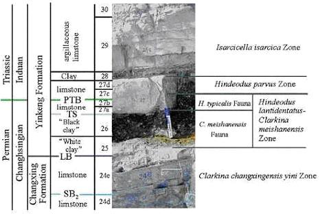
Precise evidence of the boundary between the Permian and Triassic is greatly obscured; a relatively low distribution of rocks from this period coupled with several orogenic cycles combine to limit the available rock record. (Sweet, 1992) However, a boundary between the Permian and Lower Triassic has been accepted as marked by a GSSP located in Changxing County, Zhejiang Province, South China. The boundary has been dated via radiometric dating at roughly 250 Ma: 251.2 ± 3.4 Ma using 206PB/238U analysis of "White Clay" Bed 25 and 249.91 ± 0.15 Ma using incremental-heating of 40Ar/39Ar sanidine grains extracted from Bed 25. Individual total-fusion analyses yield a mean date of 249.62 Ma (Hongfu, 2001). Although there are some lithological characteristics that allow for the distinction between the Permian and Triassic, the two periods are best separated by biostratigraphic means. This is due to the massive extinction that also defines the boundary between the Paleozoic and Mesozoic eras. (Lozovsky, 1998) The index fossil Hindeodus parvus, the horizon of which occurs at the base of Bed 27c of Meishan section 27c is often used to identify the PTB. Del13C has also been proposed as an auxiliary marker for this boundary. (Hongfu, 2001)
|
|
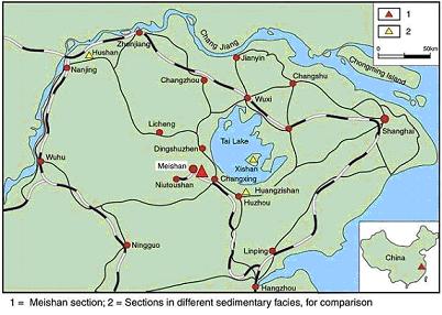
Figure: Strata at the Meishan section GSSP (Jin, 2000)