HISTORY OF THE CHAMPLAIN SEA
Development of the Basin
![]()
|
Massive ice sheets covered many parts of the world during the Pleistocene Epoch of the Quaternary Period. From about 1,600,000 years B.P. until about 8,000 years B.P., much of North America was covered by the |
|
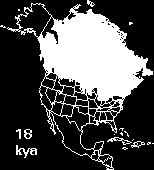 |
Laurentide Ice Sheet. At its maximum extent, this ice sheet reached as far south as the mid USA, covered an area of more than 13,000,000 square km, and had a thickness of up to 3000 m. It is believed to have originated on the Labrador-Ungava plateau and mountains of the Arctic islands of Canada, and to have been centered over Hudson Bay. The Wisconsin glaciation, the last glacial stage of the Quaternary, began its advance about 75,000 years B.P. and reached as far south as Long Island, New York. The Laurentide ice sheet began its retreat about 17,000 years B.P. and by about 12,000 years B.P., it had retreated into the St. Lawrence Lowland. As the ice moved across this |
| region, it was isostatically depressed below sea level, resulting in the Champlain Sea basin as well as many proglacial lakes. Once the ice was completely removed from the lower St. Lawrence Valley to the east, marine waters began to inundate the basin and the Champlain Sea was born. | |
![]()