Topography of the Bering Land Bridge
The topography varies on the Bering and Chukchi sea floors. Since transgressions and frequent storms have eroded some of the top layers of the land bridge paleosurface before it was submerged, the latest dates for submergence are not available. This is important because the timing of inundation of the landbridge is therefore earlier than 11,000 ya. Sea level is now rising an average of one foot per century due to climatic warming.
Reconstruction of Sea-level changes before inundation (Elias et al, 1996)
| Time(kya) | Sea-level (m) | Description |
| permanent seaway is established | ||
| most of the Chukchi sea was flooded, Bering Straight near modern size | ||
| shelf inundation removes biotic migration routes | ||
| northern Bering shelf flooded, submergence almost complete |
Stratographic Sequence of the Bering Land Bridge
The central and northern Chukchi and Bering seas cores demontrated the following stratigraphy (Elias, 1998). The landbridge sequence (the Pleistocene terrestrial sequence) were composed of in situ organic layers that were less than 5 cm to 300 cm thick. These were peats and silts which contained pollen, plant macrofossils, and insects that were used for dating and ultimately for paleoenvironmental reconstruction.
| Holocene marine deposits |
| Pleistocene terrestrial sequence | Pliocene marine? |
| Cretaceous terrestrial sequence |
Remnant Highland of the Bering Land Bridge
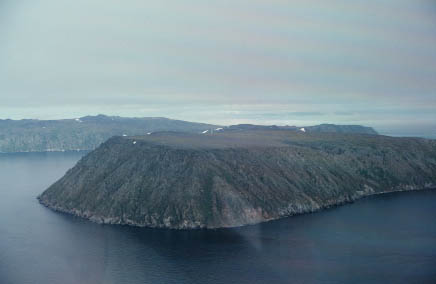
This is a remnant piece of the landbridge. It is the Little Diomede Island that is located between Siberia and Alaska. Sea-level reconstruction is currently under investigation on this island. Scientists hope to explain the different results for sea-levels determined between Siberia and Alaska. Little Diomede Island is a granitic pluton inhabited by the Inupiat Eskimo. (Source: Paleoenvironments and Glaciations website, Lyn Gualtieri)

