Exposure of the Bering Land Bridge
Sea-level The land brige has been exposed during the cold periods of the Sagamon and Wisconsinan glaciations. For most of the past 2 my the land bridge was exposed and dry because sea-level dropped dramatically when water became locked up in continental ice sheets. Eustatic (global) sea-level went down anywhere from 280 to 400 feet during the last part of the Wisconsinan glaciation. This exposed large areas of continental shelves and increased the surface area of all continents.
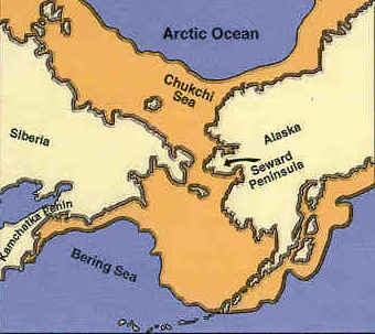
In Beringia, sea levels are estimated to have decreased 300 feet. More than a land bridge was exposed. A 1,000 km wide landmass joined Siberia and Alaska at the current site of the Bering Straight which is 55 miles across today. The shallow continental shelves and the sea bottoms of the Chukchi and Bering seas were exposed, joining the eastern and western hemispheres. Ocean circulation between the Arctic and Pacific oceans were blocked. This was a very rapid and intense event on the region of Beringia.
The Bering Sea is known for its rich and productive ecosystem that supports migrating sea mammals such as the walrus, seals, bowhead and beluga whales, and migrating fish. Aquatic migrations of flora and fauna stopped, but land migrations began. The change in ocean circulation had a dramatic effect on the regional climate in Beringia. Water temperature, wind directions, cloud patterns, and nutrient cycling changed.
Paleogeography of Beringia
Aeolian Deposits Aeolian deposits are widespread in Beringia today, and they are found in the unglaciated regions of Alaska near lowland and broad-valley segments of streams formed by glacial drainage. During the cold and dry Duvanny Yar interval of the Wisconsinan glaciation, aeolian activity was intense in both summer and winter. The aeolian deposits that remain today are windblown sand and silt that were deposited during the late Pleistocene age. Fossiliferous brown sand buried beneath outwash gravel indicates that more than one aeolian event has occured. Sand wedges, large sand dunes, and loess are characteristic of Alaskan deposits. The direction of well vegetated sand dunes of Alaska are indicators of paleowind direction. Near the Seward Peninsula, thaw-lake deposits consist of fine sand or silt that has been deposited there by the wind. A large sand sea covers 7000 km ² of the Alaskan Arctic Coastal Plain. (Source: Hopkins et al, 1982)
Permafrost Seasonal temperature fluctuations and annual average temperature are responsible for forming ice wedges from the permafrost, and small hills called pingos. Permafrost is a permanently frozen layer of ground that consists of soil, sand, and gravel frozen in a solid mass. Permafrost can reach 450 m deep and only exists in areas where the temperature rarely goes above 0 degrees Celsius (32 degrees F). When the top layer thaws, the water turns the substrate to mud, and any object on the surface can sink. The mud becomes accessible to plants, and in optimal conditions, germination of seeds will occur. Melting of loess-ice bridge have formed mounds and depressions in the landscape, and water environments such as bogs. Lossic ice is is characteristic of an arctic climate, while loess-icy-loess is subarctic (Tomirdiaro, 1998). Tomirdiaro, postulates that there was a continuous loess-covered land surface covering a permanently frozen sea ice on the Bering Land Bridge.

