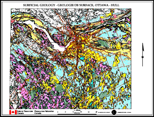
RECENT DEPOSITS
 10- ORGANIC DEPOSITS:
mainly muck and peat in bogs and poorly drained areas
10- ORGANIC DEPOSITS:
mainly muck and peat in bogs and poorly drained areas 9- MODERN RIVER
DEPOSITS: stratified sand, silty sand, silt, and disseminated organic matter on flood plaine of
present rivers
9- MODERN RIVER
DEPOSITS: stratified sand, silty sand, silt, and disseminated organic matter on flood plaine of
present rivers L- Landslide areas; includes
zones of both material removal and redeposition
L- Landslide areas; includes
zones of both material removal and redepositionPOST-CHAMPLAIN SEA DEPOSITS
 8- ABANDONED RIVER
CHANNEL DEPOSITS: silt and silty clay; commonly including lenses of sand and generally
underlain at variable depth by unit 3
8- ABANDONED RIVER
CHANNEL DEPOSITS: silt and silty clay; commonly including lenses of sand and generally
underlain at variable depth by unit 3 7- ABANDONED RIVER
CHANNEL DEPOSITS: stratified, buff, medium grained sand; unfossiliferous; locally reworked
into low dunes
7- ABANDONED RIVER
CHANNEL DEPOSITS: stratified, buff, medium grained sand; unfossiliferous; locally reworked
into low dunes 6- ESTUARINE AND
CHANNEL DEPOSITS: stratified, buff to gray, medium to fine grained sand; minor gravel
lenses; unfossiliferous; locally reworked into low dunes
6- ESTUARINE AND
CHANNEL DEPOSITS: stratified, buff to gray, medium to fine grained sand; minor gravel
lenses; unfossiliferous; locally reworked into low dunesCHAMPLAIN SEA DEPOSITS
 5- LITTORAL FACIES:
gravel, coarse sand and cobbles; containing fossils; in places composed of slabs of bedrock
where beach was derived from outcrops of Paleozoic rock. (Beaches underlain by fluvioglacial
deposits are mapped as unit 2)
5- LITTORAL FACIES:
gravel, coarse sand and cobbles; containing fossils; in places composed of slabs of bedrock
where beach was derived from outcrops of Paleozoic rock. (Beaches underlain by fluvioglacial
deposits are mapped as unit 2) 4- SUB-LITTORAL FACIES:
uniform, fine, buff sand deposited in shallow water as nearshore facies; commonly reworked into
dunes; commonly fossileferous
4- SUB-LITTORAL FACIES:
uniform, fine, buff sand deposited in shallow water as nearshore facies; commonly reworked into
dunes; commonly fossileferous 3- DEEP WATER FACIES:
blue-gray clay, silt, and silty clay; calcareous and fossiliferous at depth; commonly reworked;
non-calcareous and non-fossiliferous at surface (0-2 m) particulary in northeastern part of
area
3- DEEP WATER FACIES:
blue-gray clay, silt, and silty clay; calcareous and fossiliferous at depth; commonly reworked;
non-calcareous and non-fossiliferous at surface (0-2 m) particulary in northeastern part of
areaPRE-CHAMPLAIN SEA DEPOSITS
 2- FLUVIOGLACIAL
DEPOSITS: gravel and sand, stratified, some till; in form of eskers and various ice-contact
deposits; surface reworked into beaches in locations below the Champlain Sea marine limit
2- FLUVIOGLACIAL
DEPOSITS: gravel and sand, stratified, some till; in form of eskers and various ice-contact
deposits; surface reworked into beaches in locations below the Champlain Sea marine limit 1- GLACIAL DEPOSITS: till;
heterogeneous mixture of material ranging from clay to large boulders, generally sandy, grades
downwards into unmodified till; surface generally modified by wave or river action; topography
flat to hummocky
1- GLACIAL DEPOSITS: till;
heterogeneous mixture of material ranging from clay to large boulders, generally sandy, grades
downwards into unmodified till; surface generally modified by wave or river action; topography
flat to hummockyBEDROCK
 R2- Limestone, dolomite,
locally shale, sandstone (Paleozoic); mainly bare, tabular outcrops; includes areas thinly veneered
by unconsolidated sediments up to 2 m thick
R2- Limestone, dolomite,
locally shale, sandstone (Paleozoic); mainly bare, tabular outcrops; includes areas thinly veneered
by unconsolidated sediments up to 2 m thick R1- Intrusive and metamorphic
rocks (Precambrian); mainly bare, hummocky, rolling or hilly rock knob upland; includes areas
thinly veneered by unconsolidated sediments up to 2 m thick
R1- Intrusive and metamorphic
rocks (Precambrian); mainly bare, hummocky, rolling or hilly rock knob upland; includes areas
thinly veneered by unconsolidated sediments up to 2 m thickSource: Map 1425A (Geological Survey of Canada) http://sts.gsc.nrcan.gc.ca/page1/urban/map1.htm
