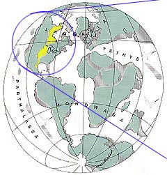
![]() During
the Late Cretaceous, a shallow seaway that extended from the Arctic
Ocean through to the Gulf of Mexico bisected North America. This
seaway was known as the Western Interior Seaway.
During
the Late Cretaceous, a shallow seaway that extended from the Arctic
Ocean through to the Gulf of Mexico bisected North America. This
seaway was known as the Western Interior Seaway.
(Lemon, 1993)
By the Late Cretaceous, Laurasia and Gondwana were almost completely fragmented and sea level was elevated worldwide.
(Lemon, 1993)
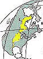
Close up: North America, Western Interior Seaway.
![]() The
climate was warm and subtropical with seasonal rains.
The
climate was warm and subtropical with seasonal rains.
![]() Alberta,
which lay around the western shore of the seaway, was criss-crossed
by rivers, estuaries, swamps and deltas that all ultimately drained
eastward into the shallow sea (Eberth, 1997).
Alberta,
which lay around the western shore of the seaway, was criss-crossed
by rivers, estuaries, swamps and deltas that all ultimately drained
eastward into the shallow sea (Eberth, 1997).
![]() The
region was slowly sinking due to tectonic forces adding new land
masses onto the western margin of British Columbia and uplifting of
the Rocky Mountains. As a result, vast amounts of sediment (and
fossils) accumulated in this setting (Eberth, 1997).
The
region was slowly sinking due to tectonic forces adding new land
masses onto the western margin of British Columbia and uplifting of
the Rocky Mountains. As a result, vast amounts of sediment (and
fossils) accumulated in this setting (Eberth, 1997).
![]() Over
the course of many tens of millions of years, the Western Interior
Seaway repeatedly expanded and contracted, leaving a record of
advancing and retreating shorelines in the form of layers of
alternating marine and non-marine sediments and fossils (Eberth,
1997).
Over
the course of many tens of millions of years, the Western Interior
Seaway repeatedly expanded and contracted, leaving a record of
advancing and retreating shorelines in the form of layers of
alternating marine and non-marine sediments and fossils (Eberth,
1997).